


11 Dec 2024
Tired Earth
By The Editorial Board
In January 2021, the World Wildlife Fund (WWF) released a report about the state of the world's deforestation problem and 24 "deforestation fronts," or places where large areas of forest are under threat. The study concluded that 106 million acres (43 million hectares) of forest around the world have been stripped away over the last 13 years.
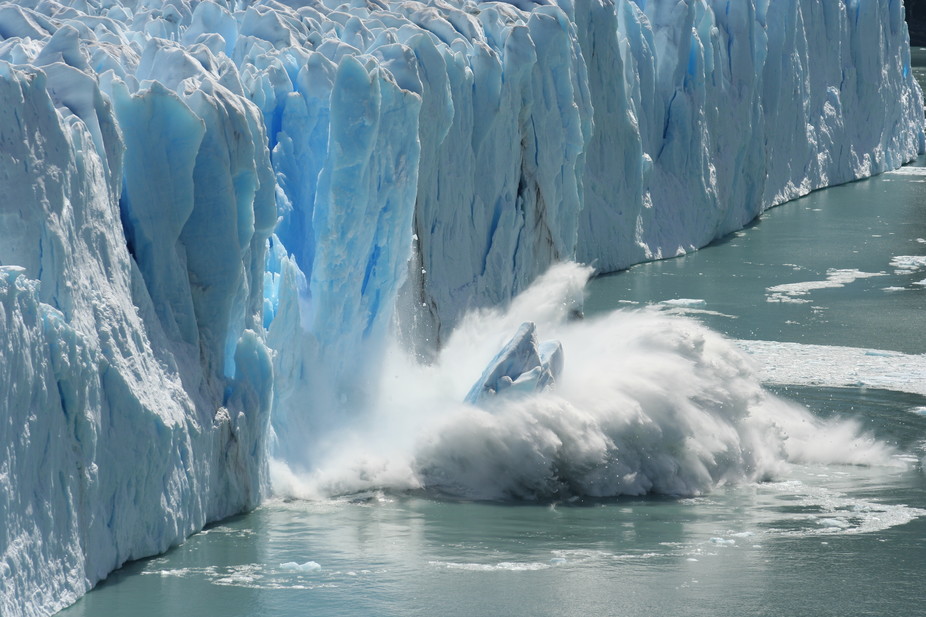
"Nature is in freefall and our climate is changing dangerously — protecting precious forests like the Amazon is a vital part of the solution to this global crisis," Tanya Steele, chief executive officer at WWF, said in a statement. Earth's forests are our planet's lungs, inhaling atmospheric carbon dioxide (CO2) and expelling breathable oxygen. This ability to absorb CO2 means that forests act as carbon sinks and store CO2 from the atmosphere, reducing the negative impact the greenhouse gas can have on global warming. Since the 1960s, Earth's CO2 sinks have absorbed around 25% of the CO2 emissions from fossil fuels, according to the BBC. For example, the Amazon rainforest stores around 1.1 to 1.3 tons (1 to 1.2 billion metric tonnes) each year, according to the BBC. of CO2, according to WWF .
However, thanks to growing global populations and an increase in demand for resources, such as fuel, food and land, deforestation is wreaking havoc on forests around the world. For example, 30 million acres (12 million hectares) of tropical tree cover was lost in 2020 alone, according to research by the University of Maryland.
Here are just a handful of these "deforestation fronts" to show the stark realization of deforestation around the world.
Indonesia accounts for only 1% of Earth's land surface, but the rainforests that cover the country's 18,000 islands are home to 10% of our planet's plant species, according to NASA. However between 2001 and 2020, Papua, also known as Western New Guinea, has lost around 1.7 million acres (666,000 hectares) of tree cover, which is equivalent to around 546 million tons (495 million metric tons) of CO2 emissions, according to Global Forest Watch. The images above show the vast forest clearing around the Indonesian Digul River; Earth-observing satellites Landsat 5 and Landsat 8 snapped the images on Nov. 20, 2002 and Nov. 27, 2019.

An aerial image of deforestation in Balikpapan, East kalimantan, Borneo. (Image credit: Getty Images )
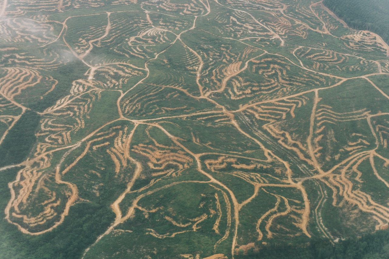
Palm tree plantations represent one of the biggest threats to the Heart of Borneo — the main part of the Indonesian island where forests are still intact, covering an area the size of Utah. As a cheap source of oil for food and fuel, palm oil is a hot commodity in Indonesia; however, palm oil has also led to the loss of at least 39% of Borneo’s tree cover, according to Reuters.
More than 90% of the global palm oil production occurs in Malaysia and Indonesia, according to the WWF. As a result, countless trees have been cut down to make way for palm plantations; as those trees have fallen, the resident wildlife populations have also suffered. Of course, human activity isn't the only threat to Indonesian forests. As global temperatures continue to increase, the occurrence of wildfires seems to be following suit, according to the Climate Science Special Report: Fourth National Climate Assessment, Volume I . In 2019, wildfires blazed through 3,311 square miles (8,575 square km) of the Borneo jungle, releasing around 690 million tons (626 million metric tons) of carbon dioxide between August and October, according to CNN.
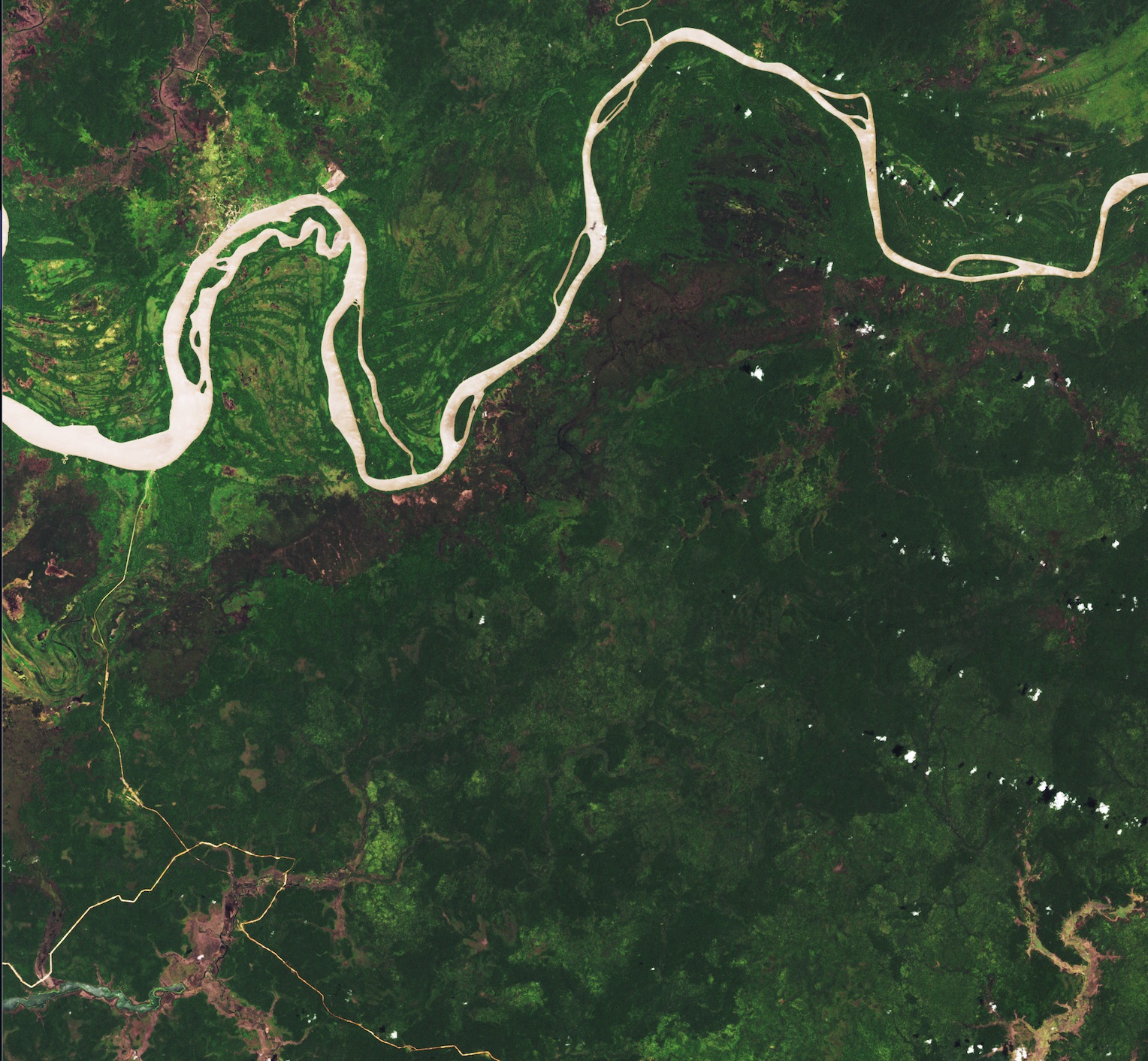
The Gran Chaco is South America's second-largest forest and is a hotspot for wildlife, providing habitat for about 3,400 species of plants, 500 species of birds and around 150 species of mammals, according to WWF. The Gran Chaco, which spans around 250,000 square miles (650,00 square km), has been subject to years of deforestation for agricultural development. Between 2010 and 2018, 11,000 square miles (29,000 square km) of forest were converted to soybean farmlands and livestock ranches, according to NASA. The image above shows a portion of the forest in the Salta Province of northern Argentina that has been stripped away and replaced with fields.
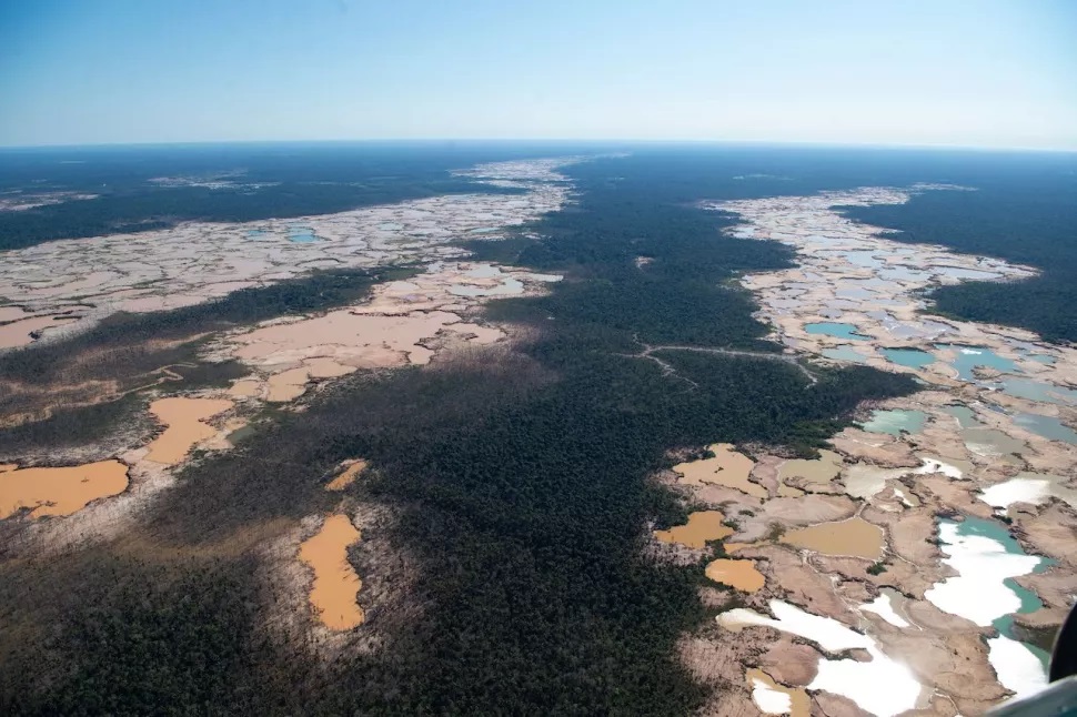
An aerial view of chemically deforestation caused by illegal mining in Madre de Dios region of southeast Peru. (Image credit: Getty Images )
Over the past 20 years, the Peruvian Amazon rainforest has been one of the most affected areas in the world by deforestation, according to the WWF. In 2015, 1,100 square miles (around 2,800 square km) of Peru’s forests were cut down each year, with around 80% of deforestation caused by illegal logging, according to the WWF. One region of Peru, called the Madre de Dios, has seen vast losses of the forest thanks to illegal gold mining. Between 2001 and 2020, the Madre de Dios region lost around 672,000 acres (272,000 hectares) of tree cover, according to the Institute of Engineering and Technology.
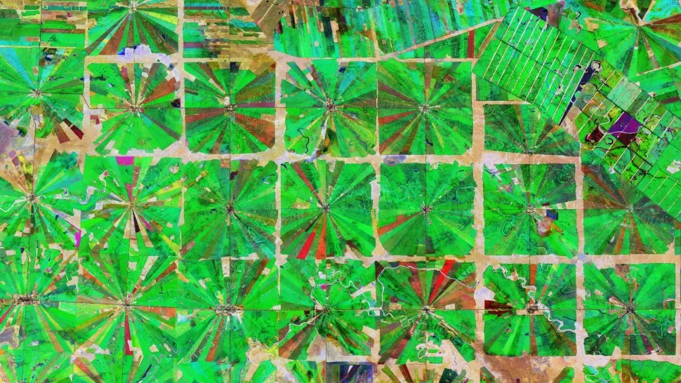
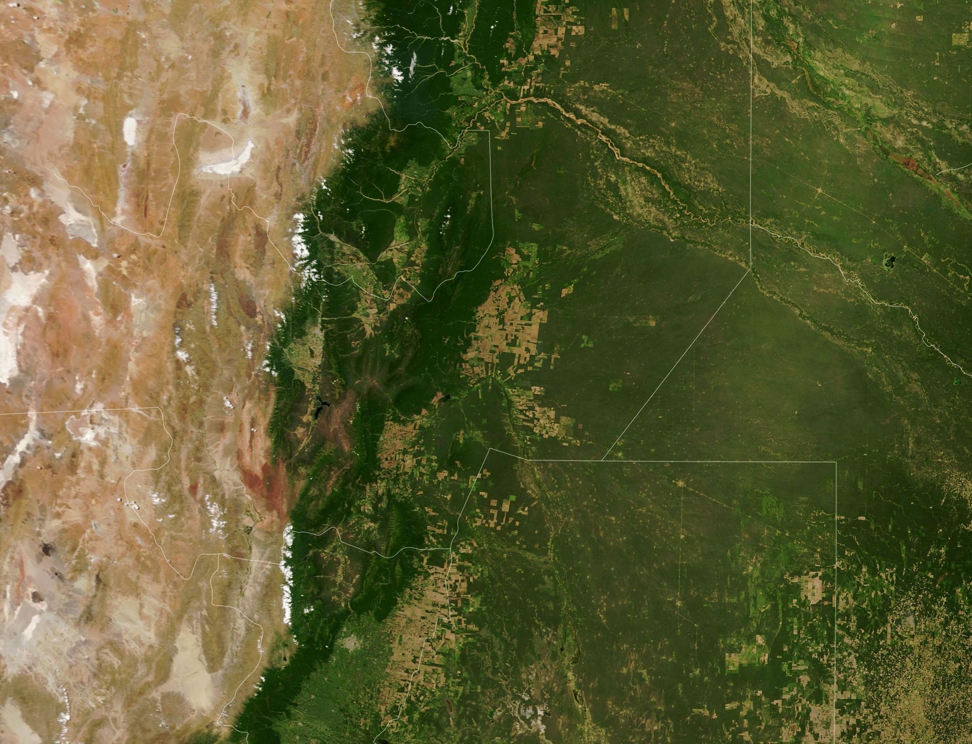
A satellite image captured by Copernicus Sentinel-2 of an area in the Santa Cruz Department of Bolivia. (Image credit: Copernicus Sentinel data (2019), processed by ESA)
Since 2000, Bolivia has lost 9.5% of its tree cover. This is equivalent to around 15 million acres (6.1 million hectares) and 2.6 gigatons of CO2 emissions, according to Global Forest Watch. In Santa Cruz, the largest of the nine constituent departments of Bolivia, vast areas of tropical dry forest have been cleared for agricultural use. This composite image was created by combining three images taken by the Copernicus Sentinel-2 satellite throughout 2019 and shows the Bolivian lowlands that have been transformed into farming communities since the 1980s, according to NASA. Each of these radial fields is around 8 square miles (20 square km) in size, with a small settlement, including a church, school and soccer field at the center of each.
(Image credit: Lauren Dauphin, using Landsat data from the U.S. Geological Survey and forest loss data from the University of Maryland)
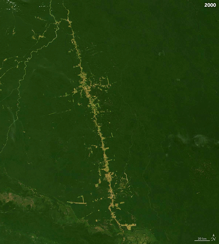
The Amazon rainforest is the largest rainforest on Earth and home to 10% of all plant and animal species. The rainforest is a part of the Amazon Biome, an area that spans around 3 million square miles (6.7 million square km) and crosses eight countries, according to WWF. Over the past 40 years, more than 18% of the Amazon rainforest found in Brazil has been lost — equal to the size of California — because of logging and agriculture, according to Greenpeace.
The images above show the amount of deforestation between 2000 and 2019 around a portion of one of Brazil's major highways, called the BR-163, according to NASA. The highway, which is over 1,000 miles (1,700km) long, links soy-growing areas in the southern Amazon rainforest with ports at the river's end, according to WWF.
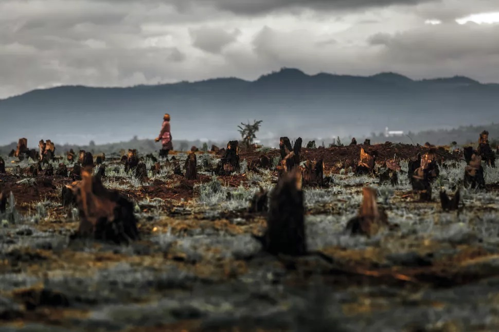
Stumps left behind slash and burn agriculture in Madagascar. (Image credit: Getty Images)
Forests throughout eastern Madagascar have been subjected to deforestation to make way for agricultural development for many years, according to research published in the journal Agriculture, Ecosystems and Environment Since 2000, the nation has lost 24% of its tree coverage, according to Global Forest Watch. One of the major causes of deforestation in Madagascar is "slash and burn" agriculture, also known as swidden. This method of deforestation involves cutting down extensive areas of forests and burning the fallen trees. Its purpose is to incorporate the biomass of the trees into the soil, thus increasing the soil’s fertility for the benefit of agricultural crops, according to the Encyclopedia of Food and Agricultural Ethics.
Source : livescience.com
The best of Tired Earth delivered to your inbox
Sign up for more inspiring photos, stories, and special offers from Tired Earth
By signing up for this email, you are agreeing to news, offers, and information from Tired Earth. Click here to visit our Privacy Policy.


Comment